
What You Need to Know
- 🌊 A massive 650-foot mega-tsunami in Greenland’s Dickson Fjord sent seismic waves detectable worldwide, marking an unprecedented geological event.
- 🛰️ Advanced satellite technology, including the SWOT mission, played a crucial role in mapping and understanding the dynamics of the fjord’s seismic activity.
- 🌍 Over 70 researchers from 41 institutions collaborated internationally, using satellite imagery and computer modeling to reconstruct the event’s impact.
- 🌡️ The event underscores the influence of climate change on geological stability, as retreating glaciers leave slopes vulnerable to collapse.
- 🚨 Authorities are considering new early-warning systems that combine satellite and seismic data to protect lives and infrastructure in remote Arctic regions.
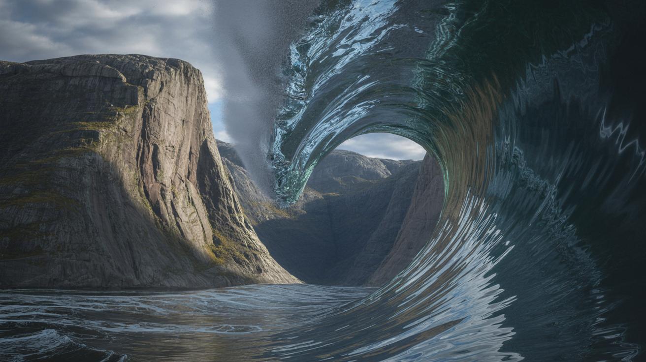
The world was taken by surprise when a massive geological event unfolded along Greenland’s eastern edge, sending seismic signals across the globe. This unprecedented occurrence was linked to a colossal landslide in Dickson Fjord, where millions of cubic yards of rock plunged into the water, creating a mega-tsunami. The impact was so powerful that it set off a unique seismic pattern, shaking the Earth’s crust from Alaska to Australia. This article delves into the details of this extraordinary event, its implications, and the scientific efforts made to understand it.
The Unfolding of a Geological Phenomenon
On September 16, 2023, a section of the mountain in Dickson Fjord gave way, releasing over 25 million cubic yards of rock and ice. This immense mass, comparable to filling 10,000 Olympic-size swimming pools, crashed into the fjord, generating a tsunami wave rising to an astonishing height of 650 feet. The ensuing wave surged through the fjord, reflecting off its walls, creating a phenomenon known as a seiche. This continuous rocking motion sent seismic waves—unlike any typical earthquake—around the world.
The seismic activity was detected by instruments globally, which recorded a slow, rhythmic pulse every 92 seconds. This pattern persisted for nine days, a testament to the energy released by the landslide. Such prolonged seismic activity from a seiche had never been observed before, making this event a landmark in geological studies.
 Continue exploring with this post : Love Horoscope For July 19, 2025 — Unexpected Revelations Shake Your World
Scientific Investigation and Global Collaboration
This rare event attracted the attention of over 70 researchers from 41 institutions globally, all eager to decipher the mystery behind the seismic signals. Scientists from various fields collaborated, utilizing satellite imagery, computer modeling, and field measurements to reconstruct the landslide and its effects on the fjord. The international effort was crucial in understanding the dynamics of the event.
Field teams measured fresh gouges on the cliffs, while supercomputers simulated the avalanche’s path and the fjord’s response. These models revealed that the landslide-driven wave was the source of the seismic signature. This interdisciplinary approach highlighted the necessity for collaborative research to solve complex geophysical puzzles, revealing the intricacies of Earth’s dynamic systems.
Climate Change’s Role in Geological Instability
The landslide at Dickson Fjord underscores the broader impact of climate change on geological stability. Greenland’s glaciers, once natural buttresses, are retreating due to rising air and ocean temperatures, leaving slopes vulnerable to collapse. This event is a stark reminder of how climate change is reshaping Earth’s natural processes, potentially leading to more frequent and intense geological events.
In 2017, a similar instability triggered a deadly tsunami in Karrat Fjord, which destroyed homes and claimed lives. As Arctic travel grows and more people traverse these remote regions, understanding and mitigating these risks becomes increasingly critical. Authorities are now exploring early-warning systems that integrate satellite data with real-time seismic information to safeguard lives and infrastructure.
Technological Advances in Monitoring Earth’s Dynamics
The Dickson Fjord event showcases the advancements in satellite technology that are transforming our understanding of oceanic and geological processes. Traditional radar altimeters have been limited in their ability to monitor vast, remote areas, but the recent launch of the Surface Water and Ocean Topography (SWOT) mission marks a significant advancement. SWOT maps wide swaths of the Earth’s surface with high resolution, providing detailed insights into places like fjords, which have long posed challenges for earlier technologies.
This technological leap allows scientists to study phenomena such as tsunamis, storm surges, and rogue waves with unprecedented detail. The data collected is invaluable for refining models and predictions, enhancing our ability to respond to natural disasters. As we continue to push the boundaries of satellite technology and data analysis, the question remains: how will these innovations shape our understanding of Earth’s ever-changing landscape?
 Continue exploring with this post : 3 Zodiac Signs Experience Unparalleled Growth & Prosperity On July 19, 2025
The Dickson Fjord mega-tsunami serves as a reminder of the dynamic and interconnected nature of Earth’s systems. It highlights the critical role of interdisciplinary research and advanced technology in deciphering complex natural phenomena. As we face the challenges posed by climate change and increasing human activity in remote regions, how will we adapt our scientific and technological approaches to better predict and mitigate such events in the future?
Did you like it?4.6/5 (20)


12 comments
David_Wisp
Wasn’t there a similar event in Karrat Fjord a few years back? History repeating itself? 🤔
janewhisperer
OMG, nature is terrifying and beautiful at the same time! Hope everyone stays safe out there.
eliana
Such a fascinating read! Thanks for highlighting the collaboration among scientists worldwide.
sophie_elysium
How effective are the new early-warning systems going to be in remote areas?
ruby8
Why was the seismic pattern every 92 seconds? That’s such a specific number.
haley
Awesome write-up! Are there any videos of the wave itself? Would love to see it in action!
AbigailOracle
650-foot wave? That’s taller than most skyscrapers! Imagine surfing that! 🏄♂️
Dylan
Does this mean we could see more tsunamis like this if climate change continues? Scary stuff!
Sasha
Can someone explain what a seiche is in simpler terms? I’m a bit lost here.
ariana
Is this the first time we’ve seen such seismic activity from a tsunami? I’ve never heard of anything like it before.
SophiaRadiance
Thank you for the detailed article! It’s amazing how technology has advanced to detect these events globally.
pipervoyager
Wow, this is mind-blowing! 😮 How are scientists planning to prevent such events in the future?